Tonga
The Kingdom of Tonga, an archipelago of 169 islands in the South Pacific, remains highly vulnerable to climate change and natural hazards. With many islands lying just a few meters above sea level, Tonga faces escalating threats from sea level rise, coastal erosion, and saltwater intrusion, which jeopardize freshwater supplies, agricultural productivity, and coastal infrastructure. On Tongatapu, the most populous island, permanent losses under a 1 metre sea level rise scenario could reach a quarter of the land area, with projections indicating up to 2 metres of sea level rise by 2150.
Tonga is also located in a seismically active zone, making it prone to earthquakes, tsunamis, and volcanic activity, in addition to climate-related hazards such as cyclones, droughts, and flooding. These overlapping risks pose serious challenges to food security, livelihoods, and the resilience of communities, particularly in the outer islands.
To strengthen its climate resilience, Tonga launched the Coastal Resilience Project (2025–2032), a US$23.9 million initiative funded by the Green Climate Fund and implemented by UNDP and the Government. It focuses on coastal protection, climate-informed planning, and community-based adaptation. This effort aligns with Tonga’s broader policy framework, including the Joint National Action Plan 2 on Climate Change, the Climate Change Policy, and the Disaster Risk Management Act and Policy, promoting proactive and integrated disaster governance.
Telecommunications infrastructure in Tonga is undergoing a major upgrade in 2025 with the construction of a second international undersea cable, a 383-kilometre branch of the Hawaiki Transpacific Cable, connecting Tongatapu to Vava’u and ultimately to Fiji. This project, supported by the Australian Infrastructure Financing Facility for the Pacific, aims to provide secure, resilient, and climate-proof connectivity, especially after Tonga’s existing cables were severely damaged by the 2022 Hunga-Tonga Hunga-Ha’apai eruption and subsequent earthquakes.
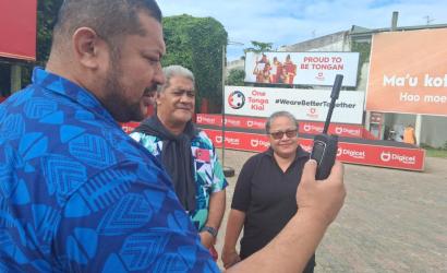
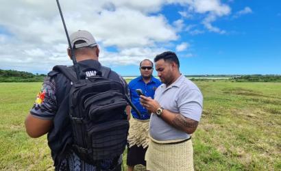
National coordination of emergency telecommunications is led by the Department of Communications of the Ministry of Meteorology, Energy, Information, Disaster Management, Environment, Climate Change and Communications (MEIDECC), working closely with the National Disaster Risk Management Office (NDRMO) to ensure timely and coordinated disaster response across the country.
ICT Profile
National Disaster Risk Management Office
Ministry of MEIDECC (Meteorology, Energy, Information Technology, Disaster Management, Environment, Climate Change, Communications)
Department of Communications
106,921
Source: https://worldpopulationreview.com/countries/tonga-population
The Kingdom of Tonga is a Polynesian country that lies to the south of Samoa, southeast of Fiji and north east of New Zealand. The Tongan archipelago is comprised of 176 islands. The islands are divided into four main groups – Tongatapu, Ha'apai and Vava'u and the Niuas.
Tonga’s climate is tropical and is defined by a wet season from November to April with moderate and variable rainfall, and a dry season from May to October. The wettest months are January, February, and March with precipitation exceeding 250 mm of rainfall per month. During the dry season, precipitation per month is less than 250 mm. The mean annual temperature in Tonga varies from 26°C to 23°C. During the wet season, the average temperature ranges from 25°C–26°C, whereas during the dry season the average temperature ranges from 21°C-24°C. Climate in Tonga and this portion of the Pacific in general is governed by a number of factors, which include the trade winds and the movement of the South Pacific Convergence Zone (SPCZ), a zone of high-pressure rainfall that migrates across the Pacific south of the equator. Year-to-year variability in climate is also strongly influenced by the El Niño Southern Oscillation (ENSO) in the south-east Pacific, which can bring prolonged drought conditions and contribute to a depletion of potable water, and tropical cyclones that occur during the wet season, causing extensive damage to local infrastructure, agriculture, and major food sources.
Sources: https://www.dfat.gov.au/geo/tonga/tonga-country-brief#:~:text=Overview,a%20population%20of%20approximately%20106%2C000.
https://climateknowledgeportal.worldbank.org/country/tonga/climate-data-historical#:~:text=Tonga's%20climate%20is%20tropical%20and,mm%20of%20rainfall%20per%20month.
Tongan paʻanga
7
59
4.73
58.7
57.3
99
Emergency Management Act (2007)
This Act provides the legal framework for all emergency and disaster risk management policies, procedure and programming in Tonga.
Source: https://ago.gov.to/cms/images/LEGISLATION/PRINCIPAL/2007/2007-0014/EmergencyManagementAct_2.pdf
Communications Act (2015)
Communication Act 2015 establishes powers and functions between the Ministry of Communications and the Regulator and their key roles by assigning procedures and regulations on how to administer the communication services across the country.
Source: https://ago.gov.to/cms/images/LEGISLATION/PRINCIPAL/2015/2015-0026/CommunicationsAct2015_1.pdf
Civil Aviation Rules (2016)
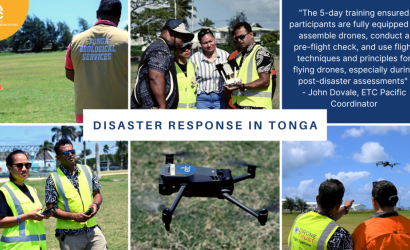
There are active drone laws in Tonga. Drones are only permitted to fly during daylight hours and drones are not permitted to fly higher than 120 meters (394 feet) above the ground.
Source: https://drone-laws.com/drone-laws-in-tonga/#:~:text=Drones%20are%20only%20permitted%20to,394%20feet)%20above%20the%20ground.
Tampere Convention
The Tampere Convention was ratified in 8 May 2003.